|
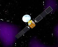
Beijing (XNA) Apr 17, 2009 China successfully launched its second navigation satellite early Wednesday, as part of the country's independent global satellite navigation system. The carrier rocket, Long March 3C, blasted off from the Xichang Satellite Launch Center in southwest China's Sichuan Province at 0:16 a.m.. An official with the National Engineering Center of Satellite Navigation told Xinhua, the successful launch of the geostationary Earth orbit satellite was of great importance as it was the second one of the country's satellite navigation system independent from foreign technology. The system, code named "COMPASS", is a crucial part of the country's space infrastructure for providing navigation and positioning services in transportation, meteorology, petroleum prospecting, forest fire monitoring, disaster forecast, telecommunications and public security among others. It can bring significant social and economic benefits, the official said. The system can help clients know their location at any time and place with accurate longitude, latitude and altitude data, and will offer "safer" positioning, velocity, timing communications for authorized users. Previous reports said China planed to complete its independent global satellite navigation system by launching about 30 more orbiters before 2015, with 10 navigation satellites into the space in 2009 and 2010. The current Compass system only provides regional navigation service within China and neighboring regions. The second "Compass" satellite and its carrier rocket were respectively developed by the China Academy of Space Technology and the China Academy of Launch Vehicle Technology which are under the China Aerospace Science and Technology Corporation. It is the 116th flight for the country's Long March series of rockets. China launched the first "Compass" navigation satellite into geostationary orbit in April 2007 to build up its own positioning system following the United States' Global Positioning System (GPS), the Galileo Positioning System of Europe and Russia's Global Navigation Satellite System (GLONASS). Related Links - GPS Applications, Technology and Suppliers
 Glenview IL (SPX) Apr 24, 2009
Navman Wireless North America announced today that its OnlineAVL2 vehicle tracking and logistics system now has the ability to pinpoint vehicles that are being underused, based on travel distance and ignition time thresholds set by the fleet manager. |
|
| The content herein, unless otherwise known to be public domain, are Copyright Space.TV Corporation. AFP and UPI Wire Stories are copyright Agence France-Presse and United Press International. ESA Portal Reports are copyright European Space Agency. All NASA sourced material is public domain. Additional copyrights may apply in whole or part to other bona fide parties. Advertising does not imply endorsement, agreement or approval of any opinions, statements or information provided by Space.TV Corp on any Web page published or hosted by Space.TV Corp. Privacy Statement |