|
|
| . |  |
. |
|
|
by Staff Writers Paris, France (ESA) Jul 05, 2012
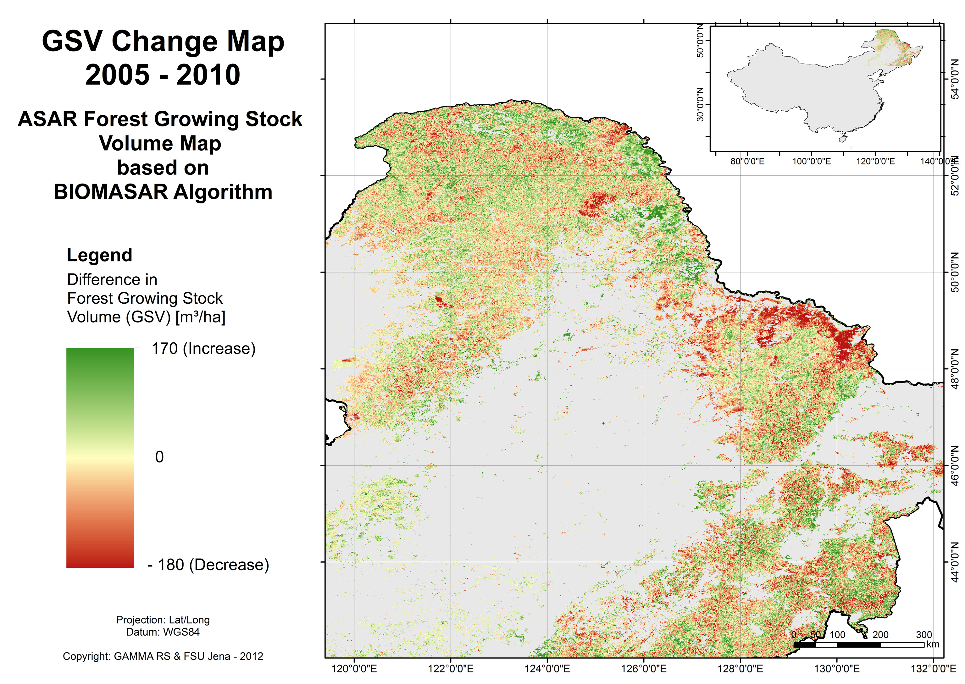
ESA and China have been cooperating through the Dragon Programme since 2004 to encourage the use of Earth observation in China. Building on the success of the past years, the programme is taking on more momentum as it enters its third phase. The Dragon Programme started in 2004 as a joint undertaking between ESA, the National Remote Sensing Center of China (NRSCC) under the Ministry of Science and Technology (MOST) of China. The aim is to promote the use of ESA, Third Party Missions and Chinese Earth observation satellite data within China for science and applications. Since its conception, the programme has grown from strength to strength. In 2004, Dragon focused on 16 projects to exploit satellite data for scientific research and different practical applications. Under Dragon 2, which started in 2008, more than 400 scientists from 165 research institutes in Europe and China were involved in 25 joint Chinese-European research projects covering land, ocean and atmospheric themes. This week, some 400 scientists gathered in China to discuss the results of Dragon 2 and mark the opening of the programme's third phase, Dragon 3. Prof. Cao Jianlin, Vice Minister of MOST, addressed the symposium stating the importance of the collaboration between ESA and China to advance science through Earth observation. "The Dragon Programme has become a model for scientific and technological cooperation between China and Europe. "Through collaborative research, advanced training courses and sharing Earth observation data, not only have applications of remote-sensing expanded, but also high level results in scientific research have been achieved." One of the largest areas of research has focused on land applications. For example, radar data from ESA's Envisat have been used to monitor forests in northeast China. Using the technique of hypertemporal imaging, scientists were able to map changes in forest cover along the Chinese-Russian border in 2005-10. The usefulness of flood monitoring has also been demonstrated through the programme. For example, 2010 proved to be a particularly bad year for floods in China but radar imagery from Envisat meant that they could be carefully monitored. In fact, using data from a range of satellites, teams were able to reconstruct changes in the dynamics of Lake Poyang in east China in the period 2003-08. Dragon has also focused on using Earth observation for monitoring air quality and water quality. Under this next phase of cooperation, some 50 projects have been selected for joint exploitation of Earth observation data. These projects involve 170 institutes and 700 researchers from both Europe and China. ESA's Maurice Borgeaud added, "The Dragon Programme is a perfect example of cooperation between MOST and ESA." "It not only enables the promotion of Chinese and European Earth observation data, but it also stimulates the collaboration between Sino-European science teams and the training of a new generation of young scientists."
Dragon training 2012
Related Links Dragon symposium 2012 Earth Observation News - Suppiliers, Technology and Application
|
|
| The content herein, unless otherwise known to be public domain, are Copyright 1995-2014 - Space Media Network. AFP, UPI and IANS news wire stories are copyright Agence France-Presse, United Press International and Indo-Asia News Service. ESA Portal Reports are copyright European Space Agency. All NASA sourced material is public domain. Additional copyrights may apply in whole or part to other bona fide parties. Advertising does not imply endorsement,agreement or approval of any opinions, statements or information provided by Space Media Network on any Web page published or hosted by Space Media Network. Privacy Statement |

 del.icio.us
 Digg
Digg Reddit
 Google