|
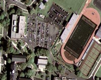
Dulles VA (SPX) Oct 13, 2008 GeoEye has released the first, color half-meter ground resolution image taken from its GeoEye-1 satellite. The satellite has been undergoing calibration and check-out since it was launched on Sept. 6 from Vandenberg Air Force Base in Calif. The Company will begin selling GeoEye-1 imagery products later this fall. Matthew O'Connell, GeoEye's chief executive officer, said, "We are pleased to release the first GeoEye-1 image, bringing us even closer to the start of the satellite's commercial operations and sales to our customers. This is a remarkable achievement, and I want to thank all of our employees, customers, especially the National Geospatial-Intelligence Agency, strategic partners, vendors and investors for their support." GeoEye-1 simultaneously collects 0.41-meter ground resolution black-and-white imagery in the panchromatic mode and 1.65-meter color (multispectral). This first image showing Kutztown University located midway between Reading and Allentown, Penn. was produced by fusing the satellite's panchromatic and multispectral data to produce a high-quality, true-color half-meter resolution image. Though the satellite collects imagery at 0.41-meter ground resolution, due to U.S. licensing restrictions, commercial customers will only get access to imagery that has been processed to half-meter ground resolution. Bill Schuster, GeoEye's chief operating officer, said, "We are bringing GeoEye-1 into service within four years of our contract award with no contract cost overruns. The entire program which includes the satellite, launch, insurance, financing and four ground stations was less than $502 million. That's the amount established and agreed to four years ago." He further noted, "GeoEye-1 is an excellent fit to meet the U.S. Government's important requirements for mapping and broad area space-based imagery collection over the next decade." Brad Peterson, GeoEye's vice president of operations, said, "This image captures what is in fact the very first location the satellite saw when we opened the camera door and started imaging. We expect the quality of the imagery to be even better as we continue the calibration activity." The Kutztown University image shows the campus, which includes academic buildings, parking lots, roads, athletic fields and the track-and-field facility. The image was collected at 12:00 p.m. EDT on Oct. 7, 2008 while GeoEye-1 was moving north to south in a 423-mile-high (681 km) orbit over the eastern seaboard of the U.S. at a speed of four-and-one-half miles per second. GeoEye-1 was built by General Dynamics Advanced Information Systems in Gilbert, Ariz. The imaging system was built by ITT in Rochester, NY. Related Links GeoEye Earth Observation News - Suppiliers, Technology and Application
 Pasadena CA (SPX) Oct 10, 2008
A NASA/university team has published the first global satellite maps of the key greenhouse gas carbon dioxide in Earth's mid-troposphere, an area about 8 kilometers, or 5 miles, above Earth. |
|
| The content herein, unless otherwise known to be public domain, are Copyright Space.TV Corporation. AFP and UPI Wire Stories are copyright Agence France-Presse and United Press International. ESA Portal Reports are copyright European Space Agency. All NASA sourced material is public domain. Additional copyrights may apply in whole or part to other bona fide parties. Advertising does not imply endorsement, agreement or approval of any opinions, statements or information provided by Space.TV Corp on any Web page published or hosted by Space.TV Corp. Privacy Statement |