|
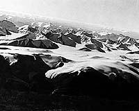
Beijing, China (SPX) Jan 22, 2009 Recent sequence stratigraphy, facies distribution, and tectonic study of 92 remnant basins in the Qinghai-Tibet Plateau reveals the Cenozoic evolutionary history of the plateau. During the Paleocene-Eocene (65-34 million years BP), the southern Tibet and the Yecheng area in Xinjiang were parts of the Neo-Tethys remnant sea where coastal plain fluvial facies dominated the hinterland of the plateau. The Sunpa-Ganzi and eastern Tibet uplifting zone shrank easterly, and tectonic uplifting took place primarily along the Bangor and the Kunlun- Altyn Tagh zone on the NE margin of the plateau. Therefore, the plateau was higher in the northeast than in the southwest. During the Oligocene (circa 34-23 million years BP), because of the uplifting of the Gangdese and Himalayan terrain and continuous uplifting along the Kunlun- Altyn Tagh -Qilian zone, the geomorphologic pattern of the region was characterized by high elevations on the SW and NE margins with low land in the central part. From the Early Miocene to the Late Pliocene (circa 23-2.6 million years BP), intensive tectonic uplifting in the Qinghai-Tibet Plateau took place mainly in South Tibet, West Kunlun, Altyn Tagh, East Tibet and West Sichuan. Within this period, two peak intervals can be recognized, 12-8 and 5-0 million years BP respectively, according to low-theomochronologic data. Apparently, the current E-W tilting geomorphologic pattern of the Qinghai-Tibet Plateau emerged during 23-2.6 million years BP. The study has been reported in Issue 11 (November 2008) of the Science in China Series D: Earth Sciences, by Ke-Xin Zhang, Guo-Can Wang, and others. The Qinghai-Tibet Plateau, the highest plateau on Earth, is the focus of multi-disciplinary studies involving the timing and mechanism for the formation of the high-plateau as well as its environmental and climatic impact. The results of this study are based on the geological mapping data of the Qinghai-Tibet Plateau collected in the last 10 years with an emphasis on temporal and spatial evolution of its sedimentary basins. Thermochronological data for tectonic uplifting in the Qinghai-Tibet Plateau during the 65-2.6 million years BP are also used in this work. This study reveals that the Qinghai-Tibet Plateau was higher in the northeast than in the southwest until early Miocene (about 23 million years ago). Thereafter, intense tectonic uplifting of the Qinghai-Tibet Plateau occurred mainly in two phases, 12-8 and 5 million years BP. As a result, the present day Qinghai-Tibet Plateau is higher in the southwest than in the northeast, showing a significant geomorphologic reversal since early Miocene (about 23 million years ago). This change to eastward tilting of the plateau is responsible for the formation of some major eastward flowing rivers in East Asia such as the Yellow River and the Yangtze River. Related Links Science in China Press Tectonic Science and News
 Columbus OH (SPX) Dec 30, 2008
Two giant plumes of hot rock deep within the earth are linked to the plate motions that shape the continents, researchers have found. |
|
| The content herein, unless otherwise known to be public domain, are Copyright Space.TV Corporation. AFP and UPI Wire Stories are copyright Agence France-Presse and United Press International. ESA Portal Reports are copyright European Space Agency. All NASA sourced material is public domain. Additional copyrights may apply in whole or part to other bona fide parties. Advertising does not imply endorsement, agreement or approval of any opinions, statements or information provided by Space.TV Corp on any Web page published or hosted by Space.TV Corp. Privacy Statement |