|
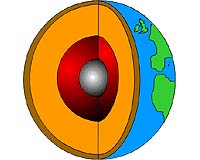
Bonn, Germany (SPX) May 01, 2008 The Earth's crust is, on global average around 40 kilometres deep. In relation to the total diameter of the Earth with approx. 12800 kilometres this appears to be rather shallow, but precisely these upper kilometres of the crust, the human habitat, is of special interest for us. Europe's crust shows an astonishing diversity: for example the crust under Finland is as deep as one only expects for crust under a mountain range such as the Alps. It is also amazing that the crust under Iceland and the Faroer-Islands is considerably deeper than a typical oceanic crust. This is explained by M. Tesauro und M. Kaban from GeoForschungsZentrum Potsdam (GFZ) and S. Cloetingh from the Vrije Universiteit in Amsterdam in a recent publication in the renowned scientific journal "Geophysical Research Letters". GFZ is the German Research Centre for Geosciences and a member of the Helmholtz Association. For many years intensive investigation of the Earth's crust has been underway. However, different research groups in Europe have mostly been concentrating on individual regions. Hence, a high-resolution and consistent overall picture has not been available to date. With the present study this gap can now be filled. By incorporating the latest seismological results a digital model of the European crust has been created. This new detailed picture also allows for the minimization of interfering effects of the crust when taking a glance at the deeper Earth's interior. A detailed model of the Earth's crust, i.e. from the upper layers to approx. a depth of 60 km is essential to understand the many millions of years of development of the European Continent. This knowledge supports the discovery of the commercial importance of ore deposits or crude oil in the continental shelf or in general with the use of the subterranean e.g. for the sequestration of CO2. It also contributes to the identification of geological hazards such as earthquakes. Related Links Helmholtz Association of German Research Centres Dirt, rocks and all the stuff we stand on firmly
 Houston TX (SPX) Apr 15, 2008
Uncovering a rare, two-billion-year-old window into the Earth's mantle, a University of Houston professor and his team have found our planet's geological history is more complex than previously thought. Jonathan Snow, assistant professor of geosciences at UH, led a team of researchers in a North Pole expedition, resulting in a discovery that could shed new light on the mantle, the vast layer that lies beneath the planet's outer crust. |
|
| The content herein, unless otherwise known to be public domain, are Copyright Space.TV Corporation. AFP and UPI Wire Stories are copyright Agence France-Presse and United Press International. ESA Portal Reports are copyright European Space Agency. All NASA sourced material is public domain. Additional copyrights may apply in whole or part to other bona fide parties. Advertising does not imply endorsement, agreement or approval of any opinions, statements or information provided by Space.TV Corp on any Web page published or hosted by Space.TV Corp. Privacy Statement |