. Solar Energy News .


.
SHAKE AND BLOW
Hurricane Irene threatens islands, US east coast
by Staff Writers
Grand Bahama, Bahamas (AFP) Aug 23, 2011

Named storms in Atlantic on record pace
Miami (UPI) Aug 23, 2011 - The number of named storms in the Atlantic this year has already outpaced last year's, which had the third-highest-ever total, forecasters say.

Tropical storm Harvey, which formed last week and is expected to drench Central America, was this year's eighth named storm while 2010 only had four at this point in the season, the Palm Beach (Fla.) Post reported.

But the numbers aren't that significant, weather experts said.

"People should not get too hung up on the where and when and how," National Hurricane Center senior specialist Jack Beven said.

Local officials said residents should remain prepared.

"This continues to underscore the message that we always preach," Palm Beach County Emergency Manager Bill Johnson said. "Have a plan, make a kit and be informed. That way you're always ready for the slowest season and the busiest season."

Florida is in its sixth year without a hurricane landfall as high-pressure systems have kept most storms off shore.

But, Beven said, "any hurricane season, we can find some weather pattern that can last a few days that can let any hurricane come to the United States."

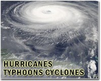
Hurricane Irene bore down on the Bahamas Tuesday as a category one storm, churning on a track that could see it slam the US mainland later in the week.

Forecasters who downgraded Irene, now packing winds of 90 miles (150 kilometers) per hour, said it could still become a major hurricane by Wednesday as it swirls past a series of islands toward the US east coast.

At 0000 GMT, Irene was centered 50 miles (80 kilometers) west-southwest of Grand Turk Island, and blasting tropical storm-force winds outwards of up to 200 miles (320 kilometers), the Miami-based US National Hurricane Center said.

Fed by warm Atlantic waters, the intensifying storm is expected to whip up ocean storm surges as high as 13 feet (nearly four meters) by the time it reaches the central Bahamas.

The storm is expected to strengthen to a major hurricane, reaching category three strength by Wednesday, the US National Hurricane Center said.

The State Department meanwhile issued a travel warning for the Bahamas and the British overseas territory of Turks and Caicos, urging US citizens already to seek shelter.

As Irene churned over the Turks and Caicos, authorities closed airports, and banks and supermarkets shut their doors.

Government spokeswoman Andrea Been said storm surges and high waves would batter the islands into the night Tuesday, while officials said high winds felled power lines and debris littered the streets of Providenciales.

In the Dominican Republic, authorities said more than 11,000 people were evacuated to shelter before the storm winds brushed the island's north coast Monday night.

Quake-ravaged Haiti, which shares the island of Hispaniola with the Dominican Republic, was largely spared by the storm, although some mudslides were reported near the northern coast.

Hurricane warnings were, however, still in effect for parts of the Bahamas, and US officials urged vigilance.

The entire eastern seaboard should be on alert, they stressed, with Craig Fugate, chief of the Federal Emergency Management Agency, urging residents to realize that it's "critical that you take this storm seriously."

National Hurricane Center chief Bill Read said a "very large" Irene would likely approach the coast of South Carolina and North Carolina early Saturday.

"But New England could also be in play for a possible impact from Irene," he warned in a media conference call.

Irene is forecast to approach the US mid-Atlantic coast at a time when it is packed with tourists for one of the final weekends of summer.

And forecasters said that by the time Irene reaches US shores, it is likely to be an even more potent storm -- perhaps as high as a category four on the five-level Saffir-Simpson scale.

"The stakes are high because it would take just a slight shift in the track to the left to make a dramatic change in the impact of the storm in a hugely populated area," said NHC spokesman Dennis Feltgen.

US forecasters said Irene could travel clear up the US Atlantic coast as far north as Delaware by early Sunday.

Up to 10 inches (25 centimeters) of rainfall were expected in the southeastern Bahamas.

Irene ravaged the US territory of Puerto Rico on Monday, and one woman died there after her car was swept away by flooding as she tried to cross a bridge, authorities said.

Some 1,500 Puerto Ricans were dislocated by the storm, and nearly a million were left without electricity. Clean-up was under way after Irene downed trees and caused flooding in residential areas.

After the storm hit, US President Barack Obama issued an emergency declaration for the territory.


Related Links
Bringing Order To A World Of Disasters
When the Earth Quakes
A world of storm and tempest

.
Get Our Free Newsletters Via Email
...
Buy Advertising Editorial Enquiries


Entire US East Coast on alert for Hurricane Irene
Miami (AFP) Aug 23, 2011 - From Florida to New England, the entire US East Coast should be on alert as Hurricane Irene could hit the seaboard with overwhelming strength this weekend, US officials said Tuesday.

"For residents in states that may be affected later this week, it's critical that you take this storm seriously," said Federal Emergency Management Agency Administrator Craig Fugate.

National Hurricane Center chief Bill Read said his forecasters' "best guess" was that a "very large" Irene would approach the coast of South Carolina and North Carolina early Saturday.

"But New England could also be in play for a possible impact from Irene," he warned in a media conference call.

Fugate said FEMA was working with North Carolina emergency official to make sure pre-landfall operations were running smoothly.

Irene, a category two hurricane since it hit the Dominican Republic late Monday after passing over Puerto Rico, could make landfall in Wilmington, North Carolina, a popular beach destination often teeming with tourists during the summer, according to US forecasters.

Experts said that by the time Irene reaches the US coast, it would likely grow into a much more powerful storm, possibly reaching category four on the five-point Saffir-Simpson scale.

The last category three hurricane to hit North Carolina, a southeastern state, was Fran, which left over 20 people dead in 1996.

In southern Florida, the tail of Irene could already be felt, with some rain and strong winds already affecting the area.

"We're very concerned about what's going to happen in New England," said Read. "Because of a high pressure system over Texas, and another in the Bermuda Azores, coupled by a weak system in between, the storm is likely to remain on track up the coast."

At 1500 GMT, Irene was lashing the Turks and Caicos Islands and dumping heavy rains and strong rains north of the Dominican Republic and Haiti as it packed winds of 100 miles (160 kilometers) per hour, with higher gusts.


. Comment on this article via your Facebook, Yahoo, AOL, Hotmail login.

Share this article via these popular social media networks
del.icio.usdel.icio.us DiggDigg RedditReddit GoogleGoogle


SHAKE AND BLOW
Hurricane Irene bears down on Dom. Republic, Haiti
Santo Domingo (AFP) Aug 22, 2011
Hurricane Irene raked Puerto Rico and barreled toward Haiti and the Dominican Republic, bringing high winds and rain to that disaster-prone rim of the Caribbean, forecasters said Monday. Irene reached hurricane strength as it passed over Puerto Rico, and at 1500 GMT packed winds of 130 kilometers (80 miles) per hour, the Miami-based US National Hurricane Center said. In Puerto Rico, the ... read more


SHAKE AND BLOW
Hydrogen cars fill up at sewage plant

A Quick Way to Grade Grasses for Ethanol Yields

Gator in your tank: Alligator fat as a new source of biodiesel fuel

Single, key gene discovery could streamline production of biofuels

SHAKE AND BLOW
Sandia Labs' Gemini-Scout robot likely to reach trapped miners ahead of rescuers

Rehab robots lend stroke patients a hand

Wearable device that vibrates fingertip could improve sense of touch

Bionic microrobot mimics the 'water strider' and walks on water

SHAKE AND BLOW
BMW to power Leipzig factory by wind energy

Chinese turbine maker enters Irish project

ACS Group sells Spain wind farm portfolio

Offshore wind power in the North Sea offer huge potential but enormous challenges

SHAKE AND BLOW
Ford, Toyota to join hands on hybrid trucks

Honda to open new Mexico plant, create 3,200 jobs

India's July car sales plunge most in nearly 3 years

China auto sales up 2.2% in July

SHAKE AND BLOW
Is oil pricing itself out of the market?

Adani's grip on Australian coal for power

Sabotage causes Nigeria oil spills, production halt: Shell

China urges protection of its assets in Libya

SHAKE AND BLOW
Miner Xstrata faces climate test case in Australiaq

Honeycomb Carbon Crystals Possibly Detected in Space

Has Graphene Been Detected in Space

Pioneers get close-up view of miracle material graphene

SHAKE AND BLOW
Iraqis face new kind of power problem

Australian Cabinet to vote on carbon tax

Berlin considers Austrian power supply ahead of winter

Iraq power plans short-circuit

SHAKE AND BLOW
Reforestation and Lions in Greece

Cambodian 'Avatars' rally to save forest

Increased tropical forest growth could release carbon from the soil

Deforestation in Brazil's Amazon up 15%


Memory Foam Mattress Review
Newsletters :: SpaceDaily Express :: SpaceWar Express :: TerraDaily Express :: Energy Daily
XML Feeds :: Space News :: Earth News :: War News :: Solar Energy News
.

The content herein, unless otherwise known to be public domain, are Copyright 1995-2011 - Space Media Network. AFP and UPI Wire Stories are copyright Agence France-Presse and United Press International. ESA Portal Reports are copyright European Space Agency. All NASA sourced material is public domain. Additional copyrights may apply in whole or part to other bona fide parties. Advertising does not imply endorsement,agreement or approval of any opinions, statements or information provided by Space Media Network on any Web page published or hosted by Space Media Network. Privacy Statement