 |
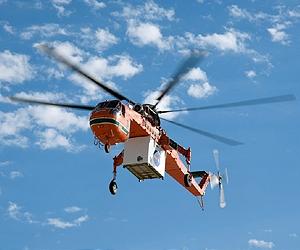
Hampton VA (SPX) Aug 20, 2010 NASA is developing technologies that will allow landing vehicles to automatically identify and navigate to the location of a safe landing site while detecting landing hazards during the final descent to the surface. This is important because future missions - whether to the Moon, an asteroid, Mars or other location - will need this capability to land safely near specific resources that are located in potentially hazardous terrain. Langley Research Center, Hampton, Va., has designed three light detection and ranging (lidar) sensors that together can provide all the necessary data for achieving safe autonomous precision landing. One is a three-dimensional active imaging device, referred to as flash lidar, for detecting hazardous terrain features and identifying safe landing sites. The second is a Doppler lidar instrument for measuring the vehicle velocity and altitude to help land precisely at the chosen site. The third is a high-altitude laser altimeter providing data prior to final approach for correcting the flight trajectory towards the designated landing area. In conjunction with laser/lidar sensor development at Langley, NASA's Jet Propulsion Laboratory, Pasadena, Calif., is developing algorithms, or mathematical procedures, for analyzing the acquired three-dimensional lidar maps and determining the most suitable landing site. The resulting Doppler lidar and laser altimeter data are used by the navigation system being developed by NASA Johnson Space Center, Houston, and Charles Draper Laboratory, Cambridge, Mass., to control the spacecraft to the identified location. These technologies have been integrated as part of NASA's Autonomous Landing and Hazard Avoidance Technology (ALHAT) project and are in the process of being demonstrated in a series of flight tests. The most recent flight tests occurred at NASA's Dryden Flight Research Center, Edwards, Calif., in July. "These were the first tests where we had all three of our laser systems on board and working together as a complete sensor suite," said Langley's Farzin Amzajerdian, technical lead for development of the sensors. "These tests are being viewed as critical by many within NASA." Robert Reisse, Langley project manager, added, "We were pleased that the flight tests we've conducted so far have resulted in better than expected performance of these sensors." The main objective of the first test, carried out in May 2008, was to demonstrate the application of 3-D imaging technology, or 'flash' lidar, for topography mapping and hazard detection. The second round of flight tests, completed in August 2008, was to evaluate the capabilities of the Doppler lidar. This lidar provides high reliability vehicle velocity vector, altitude and attitude with about two orders of magnitude higher precision than radars. The third flight test campaign was conducted in June 2009 in which the flash lidar and laser altimeter were integrated and flown onboard a fixed-wing aircraft to assess its performance for terrain relative navigation and altimetry functions. Several flights were performed in areas of Death Valley and in the Nevada Test Site with various flight profiles and altitudes reaching more than five miles above ground level. Locations were selected primarily because of topographical similarities to the lunar terrain. For the most recent field test, a Sikorsky S-64 helicopter carried all three lidar systems in a pod along with their support instruments. The flash lidar was mounted on a gimbal controlled by the ALHAT processor box that included a navigation filter built specifically for ALHAT by Draper Labs and a human interface module built by NASA Johnson. The processor box also included a 3-D elevation map generator developed by NASA JPL. NASA Johnson leads the eight-year ALHAT task, begun in early 2006, for NASA's Exploration Technology Development Program. Support is also provided by Draper Labs and the Johns Hopkins Applied Physics Laboratory, Baltimore.
Share This Article With Planet Earth
Related Links Langley Research Center Space Tourism, Space Transport and Space Exploration News
 Sailing Among The Stars
Huntsville AL (SPX) Aug 20, 2010 This fall, NASA researchers will move one step closer to sailing among the stars. Astrophysicists and engineers at the Marshall Space Flight Center in Huntsville, Ala., and the Ames Research Center in Moffett Field, Calif., have designed and built NanoSail-D, a "solar sail" that will test NASA's ability to deploy a massive but fragile spacecraft from an extremely compact structure. Much li ... read more |
|
| The content herein, unless otherwise known to be public domain, are Copyright 1995-2010 - SpaceDaily. AFP and UPI Wire Stories are copyright Agence France-Presse and United Press International. ESA Portal Reports are copyright European Space Agency. All NASA sourced material is public domain. Additional copyrights may apply in whole or part to other bona fide parties. Advertising does not imply endorsement,agreement or approval of any opinions, statements or information provided by SpaceDaily on any Web page published or hosted by SpaceDaily. Privacy Statement |

 del.icio.us
 Digg
Digg Reddit
 YahooMyWeb
 Google