 |
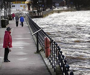
London, UK (SPX) Mar 17, 2011 Last week a team of space experts led by British company DMCii participated in a national flooding exercise, "Exercise Watermark", to determine how satellite imagery, satellite communications and satellite navigation could be used to improve UK emergency response. The team represented an ongoing project funded via the UK's Technology Strategy Board (TSB) as part of its contribution to the European Space Agency (ESA) IAP programme. Exercise Watermark was masterminded by the Environment Agency, on behalf of DEFRA and the Welsh Assembly Government, following recommendations of The Pitt Review into the flooding emergency in June and July 2007 that resulted in 13 deaths and an estimated financial cost of Pounds 3 billion. The exercise used scenarios based on severe weather conditions including flooding from the sea, rivers, surface water and reservoirs to put the UK's emergency plans to the test. During a disaster, space-based services can provide disaster response teams with up-to-date satellite maps and asset tracking capabilities to improve their situational awareness. Damaged or overloaded communications infrastructure on the ground can be reinforced using satellite telecommunications. British remote sensing company, DMCii, led the team of space experts who observed Exercise Watermark as part of the 'Integrating Space Assets for UK Civil Resilience' project. At the culmination of the 14 month project, the project team will recommend a system using space assets to improve situational awareness for the risks identified in the UK Government's National Risk Register. Adina Gillespie, DMCii Project Manager, said: "Exercise Watermark provided the team with a unique first-hand view of how a disaster is handled on the ground. We know the contingency community doesn't need to understand whizzy gadgetry, so now we're asking ourselves how can we incorporate information from space assets seamlessly into their existing disaster response procedures" During the course of the exercise, the incident command centre in Wales coordinated efforts with strategic command operators, whilst feeding into national COBRA meetings at the Cabinet Office in London. The UK resilience project's experts engaged with emergency services who are not necessarily familiar with space systems and assessed their needs. The project team also added a test activation of the International Charter: Space and Major Disasters to the exercise. As the UK's representative in the Charter, DMCii coordinated the response to requests for imagery by the Welsh Assembly Government and Cabinet Office. The European Space Agency (ESA), the Canadian Space Agency and The United States Geological Survey (USGS) and DMCii all responded to the request, supplying satellite imagery from which disaster response maps were produced. The UK resilience project benefits from a five-strong consortium. DMCii and fellow specialist Infoterra UK provide satellite imaging and mapping experience; Avanti Communications provides experience of secure back-up communications to the private sector; Nottingham Scientific Ltd. is a world leader in safety-critical satellite navigation systems and the British Geological Survey provides additional expertise on geoscience technologies related to flooding. DMCii will debrief the participants of the exercise next month, looking at how space assets were used during the exercise and how they could be better-used in future civil contingency responses.
Share This Article With Planet Earth
Related Links DMCii Earth Observation News - Suppiliers, Technology and Application
 TRMM Satellite Reveals Flooding Rains From Massive East Coast Storm
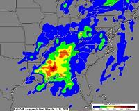
Greenbelt MD (SPX) Mar 16, 2011 The massive rain storm that stretched from New York to Florida last week dropped some record rainfall and NASA's Tropical Rainfall Measuring Mission (TRMM) satellite measured that rainfall from space. Those rainfall totals were assembled in a "rain map" created at NASA's Goddard Space Flight Center in Greenbelt, Md. Although the heaviest rainfall last week was in the southern United States ... read more |
|
| The content herein, unless otherwise known to be public domain, are Copyright 1995-2010 - SpaceDaily. AFP and UPI Wire Stories are copyright Agence France-Presse and United Press International. ESA Portal Reports are copyright European Space Agency. All NASA sourced material is public domain. Additional copyrights may apply in whole or part to other bona fide parties. Advertising does not imply endorsement,agreement or approval of any opinions, statements or information provided by SpaceDaily on any Web page published or hosted by SpaceDaily. Privacy Statement |

 del.icio.us
 Digg
Digg Reddit
 YahooMyWeb
 Google