 |
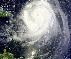
San Juan, Puerto Rico (AFP) Aug 30, 2010 Powerful Hurricane Earl bore down on Puerto Rico and the neighboring Virgin Islands Monday, growing in strength as forecasters warned it could bring dangerous waves and flash floods. Earl was raised to a category three "major hurricane" early Monday packing winds of up to 120 miles (195 kilometers) an hour, weather experts said, as thousands were left without power in nearby French islands hit by the storm. The hurricane barreling around the Caribbean was expected to harness even more power over the next 48 hours as it churns west-northwest at 15 miles (24 kilometers) an hour and heads for the US and British Virgin Islands. Midway through the annual Atlantic hurricane season, the eye of the storm passed over the French islands of Saint Martin and Saint Barthelemy early Monday, bringing down trees and snapping power lines. The French company EDF estimated some 3,500 people were left without power, and were planning to send in reinforcements from Martinique to repair downed lines. In Guadeloupe another 4,000 people had no electricity. A hurricane warning has been issued for the Puerto Rican islands of Culebra and Vieques, the National Hurricane Center said, and the storm barrelling about 265 kilometers (164 miles) east of the territory's capital San Juan. The center of Hurricane Earl was expected to whip past near the northernmost Virgin Islands later Monday, the Miami-based US center said in its latest advisory issued at 1500 GMT. "Hurricane conditions are expected within the hurricane warning areas... in this case within the next 12 hours. Preparations to protect life and property should already have been completed," the advisory said. The strong winds could whip up "large and dangerous battering waves" of over three to five feet (a meter to a meter and a half) in Puerto Rico, while the storm could dump up to 12 inches (30 centimeters) of rain in high areas. "These rains could cause life-threatening flash floods and mudslides," the hurricane center warned. Another advisory was due to be issued at 1800 GMT. The governor of the US territory, Luis Fortuno, said non-essential government services had been suspended to focus on emergency preparations. Winds of up to 140 kilometers (86 miles) an hour had already been registered in Saint Barthelemy, emergency officials in Guadeloupe said. French weather experts warned the winds could increase to 180 kilometers (110 miles) an hour and the heavy rains could last several hours. Storm surges had already flooded many districts in Saint Martin, a local journalist reported on RFO Tele-Guadeloupe. The northern half of Saint Martin is French territory, with the remainder -- known as Saint Maarten -- belonging to the Netherlands. Saint Barthelemy lies to the southeast. Prime Minister Baldwin Spencer of the nearby twin-island state Antigua and Barbuda, where a tropical storm warning remains in effect, advised inhabitants of low-lying areas to move to higher ground or into shelters. "The current weather conditions require each and every one of us to be our brothers' and sisters' keeper. Extend a helping hand to those who are in need of assistance at this time," he said. People appeared to be following his advice. Supermarkets and hardware stores Sunday reported brisk business as people rushed to get groceries, flashlights, batteries and other storm-related necessities. Current forecast models have the storm lashing the eastern US coastline early Friday, possibly reaching as far as the Canadian province of New Brunswick by Saturday. But it remained unclear whether it will make landfall. Meanwhile, the category one Hurricane Danielle, which never made landfall, continued to weaken as it sailed towards the open northern Atlantic. Observers were also eyeing a third weather system forming about 1,000 miles (1,600 kilometers) to the east of the lesser Antilles and moving west at about 20 miles (32 kilometers) an hour, amid warnings it could become a tropical cyclone in the next 48 hours.
Share This Article With Planet Earth
Related Links Bringing Order To A World Of Disasters When the Earth Quakes A world of storm and tempest
 Hurricane Danielle halts high-tech mapping of 'Titanic'
Montreal (AFP) Aug 29, 2010 A high-tech expedition has been forced to suspend its efforts to create a detailed map of the wreckage of the Titanic because of the approach of Hurricane Danielle. "It's official. Hurricane Danielle will force us to temporarily halt operations at the wreck site as of early Sunday morning," American group RMS Titanic, which holds exploration rights for the wreck, wrote on its Facebook page l ... read more |
|
| The content herein, unless otherwise known to be public domain, are Copyright 1995-2010 - SpaceDaily. AFP and UPI Wire Stories are copyright Agence France-Presse and United Press International. ESA Portal Reports are copyright European Space Agency. All NASA sourced material is public domain. Additional copyrights may apply in whole or part to other bona fide parties. Advertising does not imply endorsement,agreement or approval of any opinions, statements or information provided by SpaceDaily on any Web page published or hosted by SpaceDaily. Privacy Statement |

 del.icio.us
 Digg
Digg Reddit
 YahooMyWeb
 Google