|
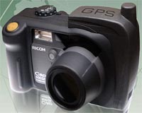
San Bernardino CA (SPX) Jun 24, 2008 Ricoh America has announced the availability the SE-3 GPS /Compass module for the Ricoh 500SE GPS Camera. Once fitted to the 500SE, the SE-3 module provides both position and direction (azimuth) information on the camera's LCD screen and embeds this data into images as they are captured for use by mapping applications such as GoogleEarth or ESRI's ArcGIS to create points where the images were captured and 'cones-of-view' that indicate the direction the camera was facing. "As the pioneer in the field of geo-imaging, Ricoh understands that image direction is a key part of many GIS workflows," said Jeff Lengyel, National Manager for Ricoh America's Digital Camera Division. "Prior to the availability of the SE-3 module, images from the 500SE were simply points on a map with no indication of the direction the camera was facing. Now we can provide an accurate visual reference of an image's azimuth as well as the field-of-view the camera could see from that position." The SE3 module utilizes a state-of-the-art 3-axis compass developed by Honeywell and a precision SiRF III GPS chipset from GlobalSat. In addition to capturing both the location and direction of an image, a 500SE fitted with the SE-3 can receive distance information from Bluetooth-enabled laser rangefinders. When these images are processed in mapping applications with Geospatial Expert's PhotoLink, the cone-of-view extends to the target object. "This enhanced capability of displaying range and/or direction provides GIS users a powerful new tool-set and a capability never before possible," said Rick Bobbit, President of GeoSpatial Experts. A multitude of industries, ranging from the military to disaster response to forestry and oil and gas currently utilize the 500SE for both aerial and ground-based photography. Related Links Ricoh Americas GPS Applications, Technology and Suppliers
 Gloucestershire, UK (SPX) Jun 23, 2008
A new weapon against cybercrime comes to market with the U.S. launch of CheckMEND. The consumer-friendly and easy-to-use online service, already well-established in Europe, offers a platform for identifying serial numbered stolen and counterfeit property offered on the Internet. |
|
| The content herein, unless otherwise known to be public domain, are Copyright Space.TV Corporation. AFP and UPI Wire Stories are copyright Agence France-Presse and United Press International. ESA Portal Reports are copyright European Space Agency. All NASA sourced material is public domain. Additional copyrights may apply in whole or part to other bona fide parties. Advertising does not imply endorsement, agreement or approval of any opinions, statements or information provided by Space.TV Corp on any Web page published or hosted by Space.TV Corp. Privacy Statement |