|
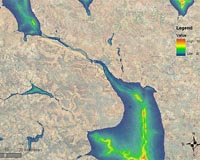
Paris, France (ESA) Jan 20, 2009 Like most sub-Saharan African countries, Niger faces problems meeting its water needs. As part of ESA's TIGER initiative, satellite data are being used to identify surface and underground water resources in the drought-prone country. Due to the rainfall variability in time and in space, during recent years the rain-fed agriculture struggles to meet the requirements of food security in the Sahel area. ESA's WADE (Water resources Assessment using SAR in Desert and arid lands in West African Ecosystems) project, funded by the Data User Element (DUE), uses ERS and Envisat Synthetic Aperture Radar (SAR) imagery to map and monitor the location and extent of surface water bodies and to identify potential areas for water infiltration. Having access to these maps will help local water authorities to better manage their water resources, lead livestock to water and improve their water storage capacity. The Advanced Computer Systems (ACS spa) in Rome, Italy, developed the WADE processing system in conjunction with local users, represented by AGRHYMET (the Regional Centre of the Permanent Interstate Committee for Drought Control in the Sahel). To demonstrate the technology, ERS and Envisat SAR data from 1993 to 2007 were integrated with in-situ data over an area of about 100 000 km� in the west part of Niger. Based on these data, a water body classification map was generated for each year. Results have been validated against 90 sampling points collected in the field by AGRHYMET during summer 2007 and showed an overall accuracy of 100% for permanent water bodies and above 75% for semi-permanent water bodies. "Permanent and semi-permanent water body monitoring is an essential resource for rangeland activities and irrigated agriculture areas in the semi-arid zone," said Issifou Alfari, AGRHYMET's Head of Water Resources Management and Desertification Division. "We are very happy with the project's scope and outcome, as we believe this source of information will be fundamental for water management activities." In November 2008, WADE software and data were installed in AGRHYMET's facilities in Niamey, Niger's capital city. Following extensive training sessions, AGRHYMET employees are now using the system to carry out their monitoring. "The WADE system fits well into AGRHYMET general activities, particularly providing accurate water resource management information at regional and national levels," Alfari said. ESA launched the TIGER initiative in 2002 to exploit Earth Observation (EO) technologies in order to respond to the urgent need for reliable water information in Africa. WADE is one of five TIGER Innovator projects, which use the latest EO technology to develop innovative, low-cost solutions to support African water authorities in the conservation and monitoring of scarce water resources. Related Links TIGER Envisat Water News - Science, Technology and Politics
 Narragansett RI (SPX) Jan 20, 2009
The water level in the Great Lakes has varied by only about two meters during the last century, helping them to play a vital role in the region's shipping, fishing, recreation and power generation industries. |
|
| The content herein, unless otherwise known to be public domain, are Copyright Space.TV Corporation. AFP and UPI Wire Stories are copyright Agence France-Presse and United Press International. ESA Portal Reports are copyright European Space Agency. All NASA sourced material is public domain. Additional copyrights may apply in whole or part to other bona fide parties. Advertising does not imply endorsement, agreement or approval of any opinions, statements or information provided by Space.TV Corp on any Web page published or hosted by Space.TV Corp. Privacy Statement |