|
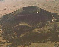
Madison WI (SPX) Oct 22, 2008 Union County New Mexico is a landscape of striking diversity. Out of expansive rangelands rise sporadic yet majestic cinder cone volcanoes and mesas preserved by basalt, part of the Raton-Clayton Volcanic Field. Capulin volcano, formed approximately 62,000 years ago, is the youngest volcano in the field. The cone rises 396 m from the plain, reaching an altitude of 2,495 m above sea level. The base of the volcano is 6.4 km in circumference, and the crater is 126 m deep and 442 m across. Four different flows of lava can be observed across the monument, indicative of different eruptive events. Conditions across the park are highly dynamic with respect to vegetation distribution, slope, and depth to bedrock, but the available soils data was highly generalized and lacked sufficient specificity to be of much use in park management of natural resources. In 2006, Dr. David C. Weindorf, Assistant Professor of Soil Classification and Land Use at the LSU AgCenter in Baton Rouge, LA, visited the volcano with a group of undergraduate soil science students. As a result of the visit, the National Parks Service commissioned a more detailed study of soils in the park. The results are published in the Fall 2008 issue of Soil Survey Horizons ("High resolution soil survey of Capulin Volcano National Monument, New Mexico" by D. Weindorf, B. Rinard, Y. Zhu, S. Johnson, B. Haggard, J. McPherson, M. Dia, C. Spinks, and A. McWhirt, Soil Surv. Horiz. 49:55-62 The unprecedented access for sampling allowed for the collection of more than 140 soil samples, the description of five soil profiles (vertical cross sections of soil extending into the subsoil). At each site, global positioning system (GPS) coordinates were recorded so the exact location of the sample could be mapped. Slope and site characteristics such as vegetative cover were also noted at each point. In the lab, soil color, texture, organic matter, pH, and other properties were carefully examined. When all datasets were complete, they were loaded into a computer program that creates interpolated maps between data collection points. In doing so, map layers were created of each data parameter. Finally, when all maps are simultaneously considered, the research team drew the boundaries of each unique soil. An additional benefit of the study was the involvement of undergraduate students. Beatrix Haggard and Stephanie Johnson, two of the undergraduate students integrally involved in the study, stated "Research on Capulin has allowed us to apply our studies in a real-world research study and prepared us for graduate research in soil science." Both students have now begun graduate work at LSU. Ongoing research at the LSU AgCenter is focusing on the validation of soils data and the use of new field portable technologies such as x-ray fluorescence (XRF) spectrometry and diffuse reflectance spectroscopy (DRS) in soil survey. Accurate soils information is vital not only to agriculture, but also civil engineering, environmental science, and other disciplines. Related Links the missing linkSoil Science Society of America (SSSA) Bringing Order To A World Of Disasters When the Earth Quakes A world of storm and tempest
 Jakarta (AFP) Oct 7, 2008
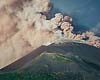
People living in the shadow of Mount Soputan volcano on Indonesia's Sulawesi island were warned to stay away Tuesday after it started erupting with smoke and flame, officials said. |
|
| The content herein, unless otherwise known to be public domain, are Copyright Space.TV Corporation. AFP and UPI Wire Stories are copyright Agence France-Presse and United Press International. ESA Portal Reports are copyright European Space Agency. All NASA sourced material is public domain. Additional copyrights may apply in whole or part to other bona fide parties. Advertising does not imply endorsement, agreement or approval of any opinions, statements or information provided by Space.TV Corp on any Web page published or hosted by Space.TV Corp. Privacy Statement |