 |
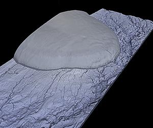
Bonn, Germany (SPX) Jul 23, 2010 On 22 July 2010, researchers at the German Aerospace Center facility in Oberpfaffenhofen published the first 3D images from the TanDEM-X satellite mission. Just one month after the launch of TanDEM-X, which took place on 21 June 2010, DLR researchers have created the first digital elevation model - almost a week ahead of schedule. A group of Russian islands in the Arctic Ocean was selected for the first test.
Precise to a few centimetres In addition, the height of a vast ice cap in the centre of the island is mapped accurately. Until now, there has been no data of this quality about this strange world. The Shuttle Radar Topography Mission, the international mission by NASA, DLR and other space agencies that flew in 2000, could not observe these polar regions - they are very important for climate research. 3D images by 'squinting' In order for 3D images and elevation models to be obtained, TanDEM-X must fly in close formation with its twin satellite, TerraSAR-X, which has been in orbit since 2007. This way, the two satellites can image the same regions of Earth's surface from different viewing angles. Close formation flying is yet to be achieved. Nevertheless, DLR researchers were able to generate the first 3D images by waiting for the optimum time when the two satellites - in their near-polar orbits - were very close together. The ground tracks - the orbits of the two satellites projected onto the Earth's surface - cross at the North Pole. When both satellites fly over this imaginary intersection at slightly different times, they come close to one another. On 16 July 2010, the researchers used this special arrangement and generated the first elevation model with the satellites 370 kilometres apart. Because this distance is still comparatively large, the radar experts had to reach deep into their bag of tricks and make the fullest use of the flexibility of the satellites. In order to simultaneously image the same area with both satellites, the antennas were not oriented perpendicular to the ground, but were tilted to one side. The two antennas 'squinted' to view the same point on Earth. The data obtained using this special antenna pointing was then transmitted to the ground. "We are relieved that these first acquisitions have worked so well. This means that already at this first stage, the interaction between the two satellites is functioning correctly, the orbits are controlled accurately and our ground systems are also working well," said Gerhard Krieger, the TanDEM-X System Engineer - he had the idea for this particular experiment.
Starting point for further elevation models "This new elevation data give an idea of the Digital Elevation Model products that will be available from the TanDEM-X mission. For the first time, one sees the small height differences in roads, field boundaries and rivers. This opens up fantastic prospects for the application of this data - for example, for the prediction of flooding areas in the event of a disaster," said the DLR engineer responsible for processing the elevation model data, Thomas Fritz.
Slowly converging in space DLR is implementing the TanDEM-X mission with funds from and on behalf of the German Federal Ministry of Economics and Technology (Bundesministeriums fur Wirtschaft und Technologie; BMWi) in a public-private partnership with Astrium GmbH.
Share This Article With Planet Earth
Related Links German Aerospace Center (DLR) Earth Observation News - Suppiliers, Technology and Application
 US state attorneys press Google in Street View probe
San Francisco, Usa (AFP) July 21, 2010 US state attorneys on Wednesday pressed Google to name workers who wrote "snooping" code that captured personal data from wireless networks while Street View cars mapped streets. "Google's responses continue to generate more questions than they answer," said Connecticut Attorney General Richard Blumenthal, part of a 38-state coalition investigating whether the search giant broke US law. ... read more |
|
| The content herein, unless otherwise known to be public domain, are Copyright 1995-2010 - SpaceDaily. AFP and UPI Wire Stories are copyright Agence France-Presse and United Press International. ESA Portal Reports are copyright European Space Agency. All NASA sourced material is public domain. Additional copyrights may apply in whole or part to other bona fide parties. Advertising does not imply endorsement,agreement or approval of any opinions, statements or information provided by SpaceDaily on any Web page published or hosted by SpaceDaily. Privacy Statement |

 del.icio.us
 Digg
Digg Reddit
 YahooMyWeb
 Google