 |
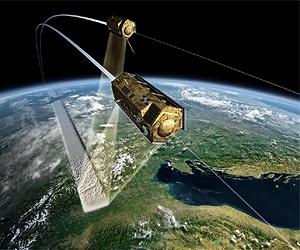
Berlin, Germany (SPX) Oct 19, 2010 The German Aerospace Center and the space company Astrium have recently taken an important step forward in their mission to create a three-dimensional map of the world. On 14 October 2010, the radar satellite TanDEM-X moved into close formation with its 'twin', TerraSAR-X. Before this, the two satellites were orbiting 20 kilometres apart - a flight time of almost three seconds. Now, there are only 350 metres separating the pair, which means their antennas are able to acquire radar images of the same area simultaneously. The objective of the mission is to create a high-precision, three-dimensional digital elevation model of Earth's land surface. The project needs the satellites to operate in parallel for a period of three years. The transition to close formation flight marks the beginning of the final preparatory stage of the TanDEM-X mission. The routine operations phase is due to start in early January next year.
"This is uncharted territory" "First, we had to manoeuvre TanDEM-X to reduce its orbital period, so that the satellite could 'catch up', reducing the 20 kilometre gap between it and TerraSAR-X. After two further manoeuvres we brought the distance between the pair down to 350 metres," explains DLR flight dynamics expert Ralph Kahle. The reduced distance between the satellites means that the two radar systems can be synchronised for the first time. TerraSAR-X and TanDEM-X can also monitor each other's 'health' via an inter-satellite link. "This is completely uncharted territory. Never before have two satellites worked in such close formation over a period of several years," says Manfred Zink, Project Manager for the TanDEM-X Ground Segment. Eckard Settelmeyer, Director of Earth Observation and Science at Astrium, adds: "This dual mission will give another boost to satellite-supported applications and science."
Radar satellites working in synchronisation "Only in this bistatic mode can we get the image quality we need for the global elevation model. It marks an important milestone in the mission," says Zink. Working in close formation, TerraSAR-X and TanDEM-X's antennas complement one another like a pair of eyes. The combination of both radar images will no longer suffer from temporal changes between subsequent acquisitions over water or forest areas, and the combined sets of data can be processed into high-quality elevation models. There are also energy-related benefits to this recording method. Because of the power consumption and build-up of heat, a radar satellite has a limit to the length of time for which it can transmit. However, in bistatic mode, TerraSAR-X and TanDEM-X share the transmission task. This means that the DLR scientists can use double the acquisition time that is available with one satellite.
Final preparations for the global elevation model In the current phase, DLR researchers will ensure that the close formation flight is optimised, the bistatic recordings are being captured correctly and the image processors are working as specified. With the successful transition to close formation flight, DLR is close to the operational phase of the TanDEM-X satellite mission.
About the mission DLR is responsible for the scientific use of TanDEM-X data, planning and managing the mission, controlling the two satellites and generating the digital elevation model. Astrium built the satellites and is sharing the costs of development and operation. As with TerraSAR-X, Infoterra, a subsidiary of Astrium, is responsible for the commercial marketing of TanDEM-X data.
Share This Article With Planet Earth
Related Links German Aerospace Center - DLR Space Technology News - Applications and Research
 An Intelligent System For Maritime Surveillance
Madrid, Spain (SPX) Oct 06, 2010 Researchers at the Universidad Carlos III de Madrid (UC3M) have designed a real application for maritime surveillance that is able to integrate and unify the information from different types of sensors and data in context through artificial intelligence and data fusion techniques. The system has been designed by scientists from this Madrid university for Nucleo CC, a company which develops ... read more |
|
| The content herein, unless otherwise known to be public domain, are Copyright 1995-2010 - SpaceDaily. AFP and UPI Wire Stories are copyright Agence France-Presse and United Press International. ESA Portal Reports are copyright European Space Agency. All NASA sourced material is public domain. Additional copyrights may apply in whole or part to other bona fide parties. Advertising does not imply endorsement,agreement or approval of any opinions, statements or information provided by SpaceDaily on any Web page published or hosted by SpaceDaily. Privacy Statement |

 del.icio.us
 Digg
Digg Reddit
 YahooMyWeb
 Google