|
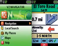
Basking Ridge NJ (SPX) Feb 12, 2009 Networks In Motion (NIM) and Verizon Wireless have announced that the Verizon Hub can synchronize locations with Verizon Wireless' popular VZ Navigator service. VZ Navigator provides customers with visual and audible directions to thousands of destinations, including businesses and other points of interest, along with maps of locations and the ability to share directions with others. Available now from Verizon Wireless, the Verizon Hub is an easy-to-use system that puts a communications command center in the home. It bridges wireline and wireless connectivity and runs on any broadband connection + whether supplied by Verizon (FiOS Internet or DSL) or any other high-speed Internet service provider. The Verizon Hub gives busy families information at their fingertips from an easy-to-navigate touch screen with on-demand access to an array of services. Several VZ Navigator-based services are available on the Verizon Hub. For example, after looking up an address using the directories on the Verizon Hub, it's easy to send a place message to any VZ Navigator-enabled mobile device using the "Send to VZ Navigator" function key. Verizon Wireless customers without a VZ Navigator subscription will receive a text message with the location information, but not the ability to access GPS turn-by-turn directions. Networks In Motion powers the VZ Navigator service and makes the integration between the Verizon Hub and VZ Navigator possible through its "Web-to-App API" technology. "The Verizon Hub is an innovative solution to help us all do a better job at managing our busy lives and navigating within our community with point-by-point directions to other contacts' locations or businesses," said Doug Antone, president and chief executive officer of Networks In Motion. "NIM's open 'Web-to-App API' allows us to assist our partners in developing features to simplify lives whether on a mobile phone or on the Verizon Hub." "Families are often running in many different directions throughout the day and need to get from place to place quickly and reliably," said Mike Lanman, vice president and chief marketing officer for Verizon Wireless. "With VZ Navigator connectivity enabled by NIM, our customers with on-the-go lifestyles can send driving directions easily from the Verizon Hub to their mobile phones, making trips from place to place even more simple." Related Links Verizon Wireless Networks In Motion GPS Applications, Technology and Suppliers
 Redlands CA (SPX) Feb 12, 2009
ArcLogistics Navigator, ESRI's in-vehicle navigation solution, keeps fleets on schedule by guiding drivers to optimized stops created in ArcLogistics. Specifically designed for trucking, fleet, and logistics applications, ArcLogistics Navigator creates a complete solution for organizations looking to plan optimum routes and schedules on the desktop and see them followed in the field. |
|
| The content herein, unless otherwise known to be public domain, are Copyright Space.TV Corporation. AFP and UPI Wire Stories are copyright Agence France-Presse and United Press International. ESA Portal Reports are copyright European Space Agency. All NASA sourced material is public domain. Additional copyrights may apply in whole or part to other bona fide parties. Advertising does not imply endorsement, agreement or approval of any opinions, statements or information provided by Space.TV Corp on any Web page published or hosted by Space.TV Corp. Privacy Statement |